Our campsite is very well placed to be up the top of Alpe de Siusi, before the road is closed at 9am. This is Europe's largest high alpine meadow, 8 miles wide and 20 miles long, separating two of the valleys we had driven – Val di Fassa and Val Gardena.
We took breakfast up with us, only to discover there were no picnic sites so ate it in the car-park. The road stays shut until 5pm, the only access being by cable-car, and we felt sure we could fill in the day with walks. As it turned out, we wondered if we would ever make it back to the car!
The first walk we did was called a Panorama walk for those in a hurry, and was an undemanding walk, that took us close to the reverse side of the peaks we are camping under. Mountain “huts” or “refuges” are encountered on the walks, and these turned out to be actual lodges with full catering facilities, very pleasant during a long walk. The advice on the web had been to visit here in June to mid July to see the spring wild flowers. We realised why mid July was the cut-off point, not the heat of summer, but the mowers were out in force, and about a third of the meadows had been cut. They were obviously 'making hay while the sun shone', and in another week, there would be no wild flowers left. This was our first experience of proper alpine wild flowers, and we found them quite stunning.
After another picnic in the car-park for lunch, we set off on a walk described in the map as more demanding, and a total time of 4.5 hours from the head of the meadow at Saltria. The excellent bus service took us to the far side of the meadow for €1, and as we knew it is 8 miles wide, a walk up to Sasso Piatto and then back to the car at Compaccio, didn't seem unreasonable.
The sun was shining, the peaks cleared of the morning mist, and we were really enjoying the walk; despite the fact that we only had shoes, not boots like everyone else! After coffee at the Zallinger Hut, we encountered a really steep track which took us up to the Sasso Piatto hut at 2300 m. (Our start point had been 1740m) The air up here was considerably colder, and although we felt like a hot drink, a guaranteed amount of liquid seemed a better use of our last money so we settled for ice-tea and a sugar boost.
At this point, we realised how sketchy the instructions were. At this furtherest point on the meadow, it merely said, return to Compaccio. No sign boards indicated which track, the track numbering system didn't help. For some unknown reason, no number 4 tracks were indicated in the direction we felt was the right one.
So at 4pm, we set of on the final leg of the journey. It had taken 3.5 hours so far, including 30 minutes of refreshment breaks. This meant we should be 1.5 hours from our car. But on the stylised map (not drawn to scale), it looked an incredibly long way. So we cranked up the pace, passing everyone we encoutered, came across numbered tracks not on our 'pretty' map obtained at the tourist information centre, and made our own way home as best we could. Some clear indication as to which of the tracks leading back to our Compaccio was the most straightforward, would have been helpful. We asked several walking parties, but they were all novices like us, and none spoke English! The best response we got from one party was where do you want to sleep tonight”, i.e. “which refuge are you heading for on your tramp”! We had no packs and only the lightest of clothing, why they thought we would be staying on the mountain was anybody's guess.
When we finally reached the car at 6.30pm, were were extremely tired, but relieved to be there. A summer jersey and lightweight shoes, didn't seem like adequate preparation for an evening in the mountains!
When we finally got back to the camp-site we were very tired and very happy to take advantage of the camp's excellent restaurant.
We were fortunate enough to secure the last terrace table, with a brilliant view over the camp nestled under the Sciliar Dolomite peak, and see the setting sun turn the peaks a rosy pink colour. It was a great finale to our last night in these mountains.
Tuesday, July 27, 2010
Bolzano and beyond – 19 July 2010
The road into Bolzano follows a gorge which makes a very dramatic entrance to the city. Bolzano is a lovely old town, full of beautiful buildings, and definitely a tourist mecca. The town was full of shops offering sales – hard to resist!
After walking the town, we set off for a lake depicted in information the London Tourist Office had supplied. In the picture, the lake looked magical, surrounded by vineyards and the reality did not disappoint. We had asked when we first arrived in the area, if there was camping near this lake, and been told, no. Well it is about time the Cesi tourist office had more information for passing tourists, as we found two campsites! But we enjoyed a picnic above the lake, and moved on to San Genesio.
San Genesio is a small town high above Bolzano, reached via an amazing road, with a spiral tunnel and bridge in one place. The drive was amazing in terms of engineering, but the town a sleepy place during siesta, with amazing views over Bolzano and the Dolomites. We found one cafe open, and enjoyed a coffee, looking out over the awesome view.
The London info, also suggested a drive to the Ega Valley. This is another gorge, which in turn leads to the Fassa Valley, and we followed this up to Lake Carezza. The lake perfectly reflects a section of the Dolomites and is an absolutely stunning spot. The trees in this area are much sort after for making excellent violins and guitars as the pine wood is so fine grained
Dolomite Drive – 18 July 2010
After a torrential storm in the night, we were pleasantly surprised to find the sun shining brightly in the morning. We set out on our Dolomites exploration using some information we had gleaned from the Internet where there was mention of a Grande Strada delle Dolomiti so, given a start and end point and a couple of hints along the way, we set off. Clearly the route can be tackled in either direction but, as we had come far enough south the previous day, it made sense to head for Belluno and then onto Cortina d'Ampezzo.
Their Roman forebears taught the Italians to build straight roads and the modern Italians have perfected this technique when it comes to mountain areas by drilling tunnels straight through the mountains, often for considerable distances. While this makes getting to one's destination much quicker, the vistas within the tunnels are distinctly, if you will pardon the pun, boring. Our aim was, thus, to avoid tunnels wherever possible and find the forgotten “back” roads to combine two pleasures: the views and the driving.
Cortina d'Ampezzo was worth a stop and stroll around, then we were off to the Pordoi Passo. This has great views from the top, but the temptation to stop too long was not appealing because of the cold temperature and the risk of the tedious slow drivers getting in front again. At the bottom of the pass, we headed for the Passa Sella This is not so dramatic, but still great mountain terrain. The close-up views of the Dolomites on both passes, were every bit as good a we had expected. Once at the bottom we decided to take a back route to Bolzano (our expected destination), but discovered Castlerotto over another small pass, and just past this small town, was a campsite sign, the first we had seen for a very long time. This seemed a good time to stop for the night, and leave Bolzano for tomorrow. We were very glad we did, as the facilities at Camping Alpe Di Siusi would have to rate as 5 star plus, in the camping world. The facilities block is underground (no danger of an unasthetically pleasing camp ablution block design marring the landscape), with a circular stairway descending to a central foyer with large fountain. Soap and toilet paper supplied (basic one would think, but not normal in Europe), deluxe toilets and showers (no token purchase necessary here!), beautifully tiled throughout, separate children's facilities, and in the women's wing, a 'marble' lined beauty room surrounded by mirrors and hair-dryers, with a water feature in the centre! Sheer camping heaven.
Off through the Alps – 17 July 2010
The beauty of our campsite was marred by the all night revellers nearby. Probably they were unable to sleep, because of the extremely hot night, so decided not to bother. We, however, slept with our tent open, and only our mosquito screen between us and the outside world. Our sleep was, thus, regularly interrupted until 5.30am when, just as the lads had quietened down, the thunder took over. We reluctantly dragged ourselves out of bed and had just got the last item in the boot when the large heavy drops of rain started.
Feeling rather pleased with ourselves, we then found the camp office was closed until 8am, so drove to the nearest town for coffee. It was a pleasant town to fill in time and after finally paying our camping fees, we set off for the Stelvio Pass. This had been one of the high-lights last year on our Alps tour, and as we were passing by that corner of Italy again, we couldn't resist a repeat of this amazing road; this time travelling in the opposite direction. Before reaching the turnoff to Stelvio, we passed through Tirano. It turned out to be a great coffee break, as the Bernina Express leaves from here, trundling along the street near our cafe, and the church is amazing, making the town well worth a visit. We were privileged to hear the organist practising for a wedding and thus enjoyed both the look and sound of the magnificent organ.
The weather was fine for the pass, we left all the bad weather behind in Como. We were amazed at the higher level of traffic on the road over the pass, then realised it was Saturday, which probably accounted for it.
After the Stelvio, we planned another mountain pass to reach the Trento area, on our way to the Dolomites. The road was empty and the mountains passes great fun to be on without the traffic. We headed for a campsite on our map, only to find it was full, as was the second camp; finally at the third camp, we were able to squeeze into a small site, unfortunately the car had to be left at the other end of camp. Rather inconvenient carrying all our stuff to and fro as we are very used to parking the car beside the tent and only unpacking the bare minimum.
Monday, July 26, 2010
On to Italy – 16 July 2010
The Montgenevre pass was just up the road from the fortified town of Briancon, which has guarded the pass for centuries. The old town is delightful to walk around, and have a coffee, and we were entertained with a re-enactment by a brigade of soldiers, who patrolled the town in full 18th century kit and gave a rifle firing demonstration.
The drive over the pass and down through the mountains on the Italian side, was the highlight of the day. The Fort Exille was the Italian counterpart of Briancon. But sadly, after leaving here, the drive settled down to very hot tedium, as we crossed the top of Italy,
Turin was wrapped in heat haze, pollution and traffic fumes so we shrugged of that Turin shroud, and moved on to Milan which unfortunately was mired in motorway madness and men and machines making more, creating mayhem and monotony as we moved maddeningly slowly around the metropolis. It was all compounded by the fact that every Italian in the city seemed to be heading north for the weekend, but eventually we reached our destination – Lake Como. We had no idea what the camping situation was like here, and after getting stuck in the continuous tunnel system above the lake, we were finally able to exit that, and found a campsite right on the water's edge, and were allocated a spot right beside the water. Life seemed to have taken a turn for the better! We were happy to be well away from Milan and it's pollution and heat; temperature gauges we passed during the day had hit the low 40s
From lavender towards the Alps – 15 July 2010
We left our delightful campsite, near a fragrant field of lavender, and visited several other towns on the lavender tour. The best coloured lavender was at Ferrassieres. Workers were out in the field of the richest colour, cutting and bundling lavender to leave it to dry in the sun, one day later and we would have missed this stunning sight.
Photographing lavender is very addictive, but we finally dragged ourselves away, and bought a picnic lunch, which we ate at a at a picnic site overlooking the really stunning hilltop town of Lurs. This town had been abandoned, but since WWII it has been restored, and is a delight to visit, quiet and calm, the tourist throng seem to have bypassed it. As our last taste of lavender, literally, we sat on a terrace in Lurs enjoying the view and a lavender ice cream.
Setting our sat-nav to take us to the border crossing with Italy, at a town called Montgenevre we had no idea what type of road we would be on, but it turned out to be wonderful gorge, with dozens of old stone bridges to cross.
A mountain pass took us over a range to wonderful views over Lac de Serre-Pancon. We unfortunately got stuck behind two logging trucks, as a result of stopping to take photos, but after winding down the mountain to nearly lake level, the sat-nav turned us off the main road (which we assume wound around the lake shore) and instead of the easy road, we had fun winding over the hills to the far end of the lake. Imagine our surprise that, when we reached the main road again, we had to give way to the first of the two logging trucks!
The lake was tempting to camp beside, but we decided to press on further, and eventually camped by a very small lake at Roche de Rame, the temperature of this lake was perfect for swimming, so a good decision.
Sunday, July 25, 2010
Start of the Lavender trail – 14 July 2010
While our tent dried out from the heavy dew, we toured south of Avignon to Les Baux. This hilltop town is built among wonderfully shaped rocky outcrops, in an area like a lunar landscape.
The town is cute, clean and quite worth a detour. On the way back to Avignon, we called by St Remy, where Van Gogh spent time in a mental ward, after slicing off his ear.
After packing our now super hot/super dry tent, we headed north-east through wonderful villages like Gordes and Roussillon to Sault, the heart of one of the lavender areas.
Gordes tumbles down a hillside, and we enjoyed our best lunch yet, of strawberry custard pie – delicious, and just outside town, we found our first lavender at the Abbey de Senanque.
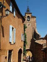
Roussillon must be paradise to an artist. The town is built of rich red to vermilion coloured clay, the whole experience was like walking through an impossibly over-the-top film set. We loved it and were reluctant to move on.
The road from there to Sault is fairly uninteresting, but once we drove to the edge of town and looked out, the view of lavender fields is great. We drove through the fields to Mount Ventoux. At 1900m the air is fresh and cold, and the 360 degree view was great, despite the heat haze.
At Sault we picked up a brochure with a selection of lavender tours, but shortly into the drive, we decided to finish tomorrow, and spend the night at a campsite at Montbrun les Bains.
Subscribe to:
Posts (Atom)