Showing posts with label UNESCO World Heritage Site. Show all posts

Saturday, August 25, 2012

Sore Necks - 24 August 2012


Our intended route for today was 90 miles which GoogleMap said would take under 2 hours: we managed to stretch that by 50% and take all day.

Our first diversion was to an overlook at the mouth of the Klamath River; the unexpected treat here was the fleet of small boats on the river with fishermen tending their nets.  The Yurok are permited to set nets in the river to catch Steelhead Salmon and they were busy hauling them out of the river.

Back on the main road for a mile or two and then off again to undertake an activity that I had first read about in a book as a child; a tree big enough to drive through.  For a mere $5 you can drive through (more than once if there is not a queue) a Coast Redwood.  The mirrors on the rental did not appear to want to fold in so, with a few cms to spare on each side, we idled through.

Our next stop was to walk a short trail at Ah-Pah where they have completely removed and rehabilitated an old logging road.  Even with before and after photos it is impossible to see where the road once was.

Ah-Pah is a short way up an alternative route to Hwy 101 which is entirely through old-growth redwoods thus providing stunning vistas at every turn.   Just before the other end is the pull off for "Big Tree", a 300ft speciman that is actually missing the top section of the main trunk.

After lunch it was time for some serious walking so from the Visitor Center we walked along the Prairie Creek trail as far as Big Tree, then took the Cathedral Trees trail back to our starting point.  Wandering along through these forest giants was the source of the sore necks as one is constantly craning to see the tops 200-300ft above the trail.  A walk like this is not recommended for those suffering vertigo.

Although the coast redwood is the tallest living entity, the cones are ridiculously small, about the size of an olive, and not the source of most new trees.  Around the base of old trees are root burls and if the old tree is stressed, new shoots sprout from the burls and because they share the established root system these new trees grow very quickly - compared to seedings from cones.  Thus it is common to see older trunks surrounded by younger trunks and on the Cathedral Trees walk there was one group that comprised at least 28 significantly sized trees plus other much smaller shoots.  All seperate trees but all the same tree.

Up Bald Hill Road is the Lady Bird Johnson Grove and interpretative walk which was most informative.

Tired out for the day we headed back to Hwy 101 and stopped in at Trinidad, a cute little spot overlooking the harbour with a copy of probably the shortest lighthouse in the world, 25', enhancing the vista.

Dinner was a particular treat; The Samoa Cookhouse is the only remaining cookhouse in the west.  Originally built around 1893  to feed the employees of the lumber company it was opened to the public in the late 1960s as a restaurant with a difference. It is still run as a cookhouse so the meal you get is the meal they are cooking that night.
The choice is to eat it or not.  The portions are lumber-jack size and although we had put in a long day in the forest the cookhouse bread, soup, salad, chicken parmesan, slab of pork, potatoes, peas and desert were a challenge and seconds were respectfully declined.  It was all you could eat for $15.95 - great value and a totally different experience.

144 miles today, total trip 6644. States: California

Friday, August 24, 2012

Rocks to Redwoods - 23 August 2012


We have thoroughly enjoyed the Oregon coast road and today was a particular highlight as we meandered from bay to bay. We began the day with breakfast at Port Orford overlooking Battle Rock, rather reminiscent of Lion Rock at Piha.  Port Orford is rather a grand name for what is essentially a wharf onto which they lift all the fishing fleet each night.
There is clearly not sufficient shelter available for the boats as southerly winds can reach 120mph and occur around three times per winter. There are apparently 5 other harbours in the world where all the boats are lifted from the sea each day.

Port Orford also has an interesting wetland boardwalk through a marsh area that has been enhanced and now functions as a filter for stormwater run-off before it feeds into a lake.  It is well done and an interesting diversion.

Hwy 101 provides viewpoint after viewpoint, some beside the road, others down short side roads. Otter Point was a wild wind-swept landscape with erosion eating away at the cliffs and another sea-stack well on the way to completion by the relentless waves.

Sea-stacks are a feature of this section of the coast, providing great habitats for the seabirds.  Although the wind got fairly brisk early on, we were still able to pick out the occasional whale spout.

We walked all the way down to the Natural Bridges, hoping for a better photo angle than was provided by the easily accessible boardwalk; only to find that the track took you to the top of the bridge allowing access to walk across the two, if you so desired, but we were still well above sea-level and obviously it is rather hard to take a picture looking out to sea through the natural arches when you are standing on top of them.

Just as we approached the state border we could see the sea-fog forming offshore and billowing in across the land, obliterating views ahead.  It is amazing how localised this effect is here and it is a significant factor in the presence of the Redwoods as we learnt in the introduction video that the sea-fog supplies 50% of the redwoods' moisture for the year, even though 100 inches of rain fall in the winter.

All to soon we were over the border into California, until we arrived at the first petrol station and saw the price. A quick u-turn and we retreated to Oregon for petrol that we had previously considered too expensive; it was now an absolute bargain.

With the tank full, we set off to enjoy a fabulous drive through the Redwood State Park and then an easy interpretative walk amongst these forest giants.  They really are most impressive and we look forward to seeing more further down the coast tomorrow.

151 miles today, total trip 6500.  States: Oregon, California

Monday, August 13, 2012

Coming back from the sun road - 12 August 2012

The day had a very early false start when the alarm sounded at 0200. A meteorite shower was occurring and the sky was partly cloudy when we turned in. We were told 0200 would be the best time and since there is almost zero light pollution in this part of Montana we decided it was worth a wake-up call.  We saw total overcast and went back to bed, to wake to a cloudless sky in the morning. Nature can be cruel sometimes!

In the trip planing we had decided to follow the Wise Men's example and return by a different route and I was sure that I had read the West to East was the best way to make the trip over Going-to-the-Sun Road.  In endeavouring to confirm that detail I found so many comments that suggested both ways were good and since the day dawned cloudless we decided to enjoy the views along Going-to-the-Sun Road in the opposite direction.

As before there were plenty of stops for photos and a walk to Sun Point and the Barring Falls.  All in all a slow, relaxing and fantastically scenic day.

After checking in at Whitefish we set off to see the town which has had the main shopping street remodelled, reasonably recently by the look of it. It is really very quaint and well done making it a most appealing looking town.
After attempting to access the lake and finding our way blocked by a fee required State Park, we stumbled upon the town beach which was free and enjoyed a refreshing dip in this surprisingly warm glacial lake followed by picnic dinner in a gazebo overlooking the lake.

97 Miles today, total trip 4930. States: Montana.


Sunday, August 12, 2012

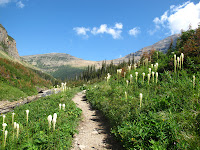
Going-to-the-Sun-Road - 11 August 2012


This romantically named road was carved out of the mountainsides in the 1930s and is now a National Civil Engineering Landmark, a National Historic Landmark and is on the Register of Historic Places, the only road in the US with all three designations.

The name comes from 2939m high Going-to-the-Sun Mountain which dominates the central part of the drive.

Apparently referred to as the Mt Everest of routes for motorcyclists, it is not really a patch on the alpine passes of Europe for driving fun, but a great drive, nevertheless.

There are ample pull-off places for photography stops but only one major carpark at Logan Pass.  The info says that the carpark is full by 10:30 and that was certainly our experience. Within 15 minutes of our arrival, there was not a park to be had and 2 hours later when we were about to leave the
"vultures" were circling ready to pounce on anyone looking like they were heading for a vehicle.  I considered offering our park on eBay but there was no 3G signal, scuppering a fantastic money-making proposition.


It is only 50 miles from end to end but photo stops and walks extend the trip to fill the bulk of the day quite easily.  To round off the day we drove north from St Mary to the booming metropolis of Babb (Pop. 1 horse) and then up to Many Glacier where we went bear hunting and if we had been lucky enough to capture a shot of
Goldilocks we could have completed the set as we were privileged enough to see a big old daddy grizzly and a mother black bear with a cub. Because we spent too long snapping the grizzly we missed the spectacle of a moose ambling over the road and swimming across the lake to the other side.  When we arrived the moose was still distinguishable on the far shore, about a kilometre away..
The bears were totally oblivious to their furiously snapping adoring public as they occupied themselves working their way through their quota of 100,000 huckleberries per day that they eat during the summer to prepare for the winter hibernation.

107 miles today, total trip 4833  States: Montana