Sunday, August 05, 2012

Carved in stone - 3 August 2012

As the morning light is the best time to see Mt Rushmore so we motored the few miles to the mountain first thing. They operate a great con here for car parking. Top price is $11 for an annual car park pass which sounds like a terrific bargain until you find that it is for a calendar year - great if you buy in January and terrible if you buy at Christmas.
The other small problem is that it is the only pass available, so a day parking costs the same as a year! How many tourists return withing the same calendar year?

Nevertheless it is the only fee you have to pay to access the park and all the facilities and displays at the National Memorial so $5.50 each for admittance to a stunning historical site like this in the US is a good deal.

Seeing the faces "up-close" is quite awe inspiring. It is just as well that the mountain was carved when it was as there is no way the environmentalists would allow it these days. The eyes are amazingly clever and yet such a simple technique to bring life to the stone.

Having fully got our $5.50 worth we mossied on around some of the roads we travelled yesterday then cut through the middle of Custer State Park to visit the Crazy Horse monument; a work in progress rather than the not quite completed presidential monument.

This project is stunningly huge in scale and although only the head is completed it is still worth a visit. The visitor centre has heaps of information, artifacts, souvenirs and displays on American Indian life.

Mt Rushmore took 17 years to get to its current form before war stopped play in 1941. Crazy Horse began in 1948 and is still going with decades of work  yet to do. Mt Rushmore had a federally funded team of workers, Crazy Horse had one lone self-funded carver for many many  years working with old and decrepit equipment but is now funded by the visitor centre and some Indian Casino money so is making faster progress.

Being 3 miles from one and 9 from the other we had a decision to make as to which to return to for the evening light show.  We chose  the closest, Mt Rushmore and were treated to some entertaining trivia by a ranger followed by a stirring patriotic speech about Washington's "unborn millions" and the WWII US Japanese Regiment which I had never heard of and which served with distinction in Europe.
Then there was a film about the four presidents, the lighting of the monument, all very static - not a laser show as promised at Crazy horse, followed by singing the National Anthem and lowering of the flag and then all military personnel past or present were invited on stage and personally acknowledge for their part in defending freedom. It was all a bit 'maple-syrup' and I almost expected an "altar-call" to come forward and sign up or take the oath of allegiance.

50 miles today, total trip 3226. States, South Dakota

Friday, August 03, 2012

Pines and Needles - 2 August 2012


Leaving the White River campsite we headed back along  SH240 for one last trip along the scenic highway through the Badlands and on to Wall for another couple of 5c coffees.

Back on the I-90 the plains gave way to hills and valleys, the acres and acres of corn gave way to dozens and dozens of Harley Davidsons.  The guide book actuallly suggests avoiding this area in August because of the Annual Sturgis Motorcycle meet.
This year some 800,000 bikers (yes, that is the correct number of zeros) will congregate here for a series of events in and arround Sturgis. We have not got to Sturgis yet but for the last few days the number of Harleys en-route has been steadily increasing and today it was wall to wall Harleys.

Before long we had reached the environs of Rapid City which we skirted on a ring motorway and headed south through the pine forests of the Black Mountain National Forest for Custer State Park.

The rest of the day was basically spent wozzling along the scenic drive, stopping at every pull-off and scenic overlook as we made our way around the park looking at bison, burros and bikers on a simply bewildering array of beautifully presented Harley Davidsons.

There was the odd other make of super-bike, Victory, Can-am trkies, massive Triumphs, big BMWs and the very rare Japanese make, but 99% were Harleys and wherever we stopped the distinctive sound of the Harleys reverberated through the forest.

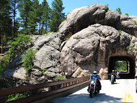
Along this fantastic drive there are very narrow tunnels carved out of the granite, switchbacks and  wooden trestle bridges where the road loops back over itself to cope with the terrain and our very first view of the Mt Rushmore faces.
Ultimately we got to the Cathederal Spires, the Littel Devils Peak and the Needle.  The rocks and views in Custer State Park are quite fantastic.

194 miles today, total trip 3176. States: South Dakota

Badlands - 1 August 2012


For a change, we were not awoken by rain or a thunderstorm, this morning it was a woodpecker; rat-tat-tatting away on a nearby tree that heralded the morning.  Since the temperature yesterday had peaked at 107F we decided that a walk in the cool of the morning would be preferable to in the baking daytime heat.

So, abandoning breakfast etc we set off to walk some trails in the Cedar Pass area.  The first one was 2.4km out and back walk to a spectacular view overlooking the White River valley. This walk included a climb up a steep slope aided by a "rope ladder" comprised of steel wire hawsers and sections of 150mm diameter logs as treads. It was much easier to ascend than descend.

The second walk was shorter, over a less well defined trail and equally but differently spectacular. While the first walk had been between peaks, the second walk was basically a plateau and the features and views were ravines.

With the sun rising (along with the temperature) we set off for the town of Wall, so named because of its proximity to the wall or escarpment that creates much of the Badlands scenery.  This drive took us through the rest of the scenic sections of SH 240 that is the main road through the Badlands National Park.

We needed to visit Wall for a number of reasons; fuel - the dashboard display told me I had 24 miles to empty when I parked on the petrol station forecourt - just a bit close for comfort in this hot and inhospitable terrain; breakfast for us (although it was nearly mid-day by now; and to visit Wall Drug for 5c coffee and free ice-water.

Wall Drug is advertised on billboards along the I-90 for the whole width of  South Dakota so there is no excuse for not being aware of its existence.  In 1936 a struggling drugstore owner's wife came up with the idea of offering the motorists on the nearby SH 16 (on their way to see the newly unveiled sculptures on Mt Rushmore) free ice-water (not a lot of air-conditioned cars back then!) and they came in droves.

Some just took the free water, but many purchased ice creams and other goods and the store has flourished ever since.  The son took over and offered the 5c coffee but the place is really a huge emporium of tourist tat - the donuts, however, are fantastic! It is set up as a wild-west outpost with lots of cheesy stuff and heaps of historical memorabilia, all in all quite a pleasurable stopping point.

Having had the free ice-water and a couple of cups of 5c coffee, we duly purchased something else - the donuts - and then found a regular store for some milk for what was now brunch.

We headed back the way we had come, stopped off at the ranger station to watch the video, came out 20 minutes later into fearsome wind, blowing in the direction which would be straight into our tent which we had left with the front flap open because of the heat.  We made a dash back to the campground to find the poor old tent being severely battered by the breeze and fastened down every guy rope and fixing point that we typically do not use.

The camp owners assured us that the severe thunderstorm warning that they had been monitoring was over in an hour and that according to the weather radar, the storm had passed so we left the tent up and set off for the White River section of the park.
This turned out to be a wasted drive as there was nothing extra to see down there.  We returned by a different route in the hope of seeing bison but had to be content with Prairie Dogs and Bighorn sheep.

By now the scattered clouds had cleared and the sunshine was illuminating the landscape brilliantly so we slowly made our way back to camp through the park once more, had a quick dinner and then set out to capture some sunset shots to round off a good day in bad lands.

Thursday, August 02, 2012

Great Plains - 31 July 2012

Leaving Jackson we headed back to the I-90 to continue our westward run across the Great Plains.  In my mind the Great Plains were a lot flatter than they are in real-life.  On the macro scale they are certainly flat and there are no hills to be seen anywhere except around the Missouri River, much like the change in topography that we noticed as we crossed the Mississippi River yesterday.

But, before we got to the Missouri there were miles and miles and miles of corn to drive past.  Later the "corndom"  was interspersed with sunflowers and cereal crops - most of which had been harvested so the fields were dotted with round bales of straw.

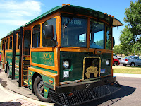
Our first stop for the morning, for our senior coffee, was the city of Sioux Falls and today, the falls were still there and a lovely park has been created around the falls by the city council.  A free "trolley" takes you to the city centre or you can simply stay on the trolley, enjoy the self-guided tour in the leaflet and return to the Falls Park, which is what we did.

Back on the Interstate there was corn and more corn.  Did I mention the corn?  And corn was the theme of the next break at Mitchell where we deviated to look at the Corn Palace.  First started in 1896 and rebuilt, enlarged and shifted a number of times, this civic space has been re-decorated with corn murals  nearly every year since.
The murals are made from 275,000 corn cobs of 12 different colours which are specially grown on a 100 acre farm nearby.  Supplementing the corn cobs is rye straw and highlights picked out in dark red/brown dock flowers.  It is pretty spectacular and even better, it is free.

The next feature of note was to "cross the wide Missouri" (break into song here), but before doing so we pulled off in the little town of Chamberlain  for a photo shoot.

We still had 150 miles to cover (past the corn fields) to our destination in the Badlands but fortunately we crossed another time zone and added an hour to our day so we arrived in plenty of time to have a first look at this utterly fantastic landscape, set up camp, have dinner and then drive back again for some sunset shots.

432 miles today, total trip 2752. States: Minnesota, South Dakota.  

Tuesday, July 31, 2012

Old Man River - 30 July 2012

Today was going to be a long day so after being woken by rain (again!) we were on the road nice and early, heading due west on Route 8 bound for Stillwater and what we thought was the Mississippi.  

Before long the lakes gave way to pasture and the conifers were replaced by corn.  Miles and miles and miles and miles of corn fields interspersed with a few fields of lucerne, beans and grass - but mainly corn (or maize?)

Our first stop was the town of St Croix Falls on the "Mississippi" but when we arrived we discovered that the falls disappeared in the early 20thC when the "falls" (a series of rapids) were flooded for a hydro dam, and that the river was actually the St Croix, a few miles upstream from where it joins the Mississippi.

Nevertheless, it was a great lunch stop and we followed the St Croix river downstream to Stillwater, which was not as appealing as the guide books lead us to believe, so we pressed on down the Great River Road, now following the real Mississippi.

Leaving St Croix Falls we crossed from Wisconsin into Minnesota and there was a dramatic change in the topography and scenery.  The flatish land of Wisconsin became quite hilly and all covered with broadleaf trees.  This continued until we finally left the Mississippi so was probably more associated with the fact that we were in a river valley system than any artificially created State boundary.

We followed the Mississippi south-east (effectively losing ground) down as far as Winona where we dropped down to get on to the I-95 for another boring long straightish westerly run for 170 miles across Minnesota to a town in the middle on nowhere called Jackson.  (Cruise control is a wonderful thing!)  

532 miles today, total trip 2320. States: Wisconsin, Minnesota

Follow the trail

Monday, July 30, 2012

Lake Superior - 29 July 2012

This morning was another fairly early start as we decided to fit a boat-trip into the day.  The campground offered all-you-can-eat pancakes for a reasonable price so we took up that offer then set out to travel almost exactly due west along miles and miles of seemingly endless straight roads.  (One section was 25 miles without a bend.)

We tend to think that NZ's South Island is uninhabited and the roads are empty but it is not alone in this regard. Today was mile after mile with hardly any traffic and long periods when there was not another vehicle in sight in front or behind.   With the cruise control set at 60mph it felt as if we were idling along at 30 as we
passed through an ever changing vista of pines, lakes, forests, swamps and so forth.  To begin with the Lake views were all of Lake Superior but as we neared our destination in Wisconsin the lakes dotted along the road became more frequent as there are over 11000 lakes in this State.

But, back to the boat-trip: We drove an hour west to Munising and arrived 10 minutes before the first sailing of the day for the Pictured Rocks boat trip.  This 2:40 hour trip takes you along the full length of the Pictured Rocks National Park.  The "rocks" in question are actually cliff faces rising up to 200' above Lake Superior and we had an absolutely beautiful morning to enjoy this delightfully relaxing trip with a witty and informative commentary and the views.
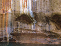
The cliff faces are stained with the leachate from various mineral deposits in the ground; iron (red), manganese (black-white), limonite (yellow-brown), copper (pink-green) and tanin from the ground above (brown). People "see" shapes or pictures in the resulting patina of colours hence the name "Pictured Rocks".  Erosion has also created a number of shaped rocks and outcrops which have been given names, most fairly obvious, like 'The Vase' and 'Indian Head'

Back on shore we made a short detour to take the walk to Munising Falls and have some lunch before setting off for the very pleasant drive to our most delightful campsite yet and the prettiest spot on this trip that this blog has been written.

240 miles today, total trip 1788. States Michigan, Wisconsin.