Friday, August 03, 2012

Badlands - 1 August 2012


For a change, we were not awoken by rain or a thunderstorm, this morning it was a woodpecker; rat-tat-tatting away on a nearby tree that heralded the morning.  Since the temperature yesterday had peaked at 107F we decided that a walk in the cool of the morning would be preferable to in the baking daytime heat.

So, abandoning breakfast etc we set off to walk some trails in the Cedar Pass area.  The first one was 2.4km out and back walk to a spectacular view overlooking the White River valley. This walk included a climb up a steep slope aided by a "rope ladder" comprised of steel wire hawsers and sections of 150mm diameter logs as treads. It was much easier to ascend than descend.

The second walk was shorter, over a less well defined trail and equally but differently spectacular. While the first walk had been between peaks, the second walk was basically a plateau and the features and views were ravines.

With the sun rising (along with the temperature) we set off for the town of Wall, so named because of its proximity to the wall or escarpment that creates much of the Badlands scenery.  This drive took us through the rest of the scenic sections of SH 240 that is the main road through the Badlands National Park.

We needed to visit Wall for a number of reasons; fuel - the dashboard display told me I had 24 miles to empty when I parked on the petrol station forecourt - just a bit close for comfort in this hot and inhospitable terrain; breakfast for us (although it was nearly mid-day by now; and to visit Wall Drug for 5c coffee and free ice-water.

Wall Drug is advertised on billboards along the I-90 for the whole width of  South Dakota so there is no excuse for not being aware of its existence.  In 1936 a struggling drugstore owner's wife came up with the idea of offering the motorists on the nearby SH 16 (on their way to see the newly unveiled sculptures on Mt Rushmore) free ice-water (not a lot of air-conditioned cars back then!) and they came in droves.

Some just took the free water, but many purchased ice creams and other goods and the store has flourished ever since.  The son took over and offered the 5c coffee but the place is really a huge emporium of tourist tat - the donuts, however, are fantastic! It is set up as a wild-west outpost with lots of cheesy stuff and heaps of historical memorabilia, all in all quite a pleasurable stopping point.

Having had the free ice-water and a couple of cups of 5c coffee, we duly purchased something else - the donuts - and then found a regular store for some milk for what was now brunch.

We headed back the way we had come, stopped off at the ranger station to watch the video, came out 20 minutes later into fearsome wind, blowing in the direction which would be straight into our tent which we had left with the front flap open because of the heat.  We made a dash back to the campground to find the poor old tent being severely battered by the breeze and fastened down every guy rope and fixing point that we typically do not use.

The camp owners assured us that the severe thunderstorm warning that they had been monitoring was over in an hour and that according to the weather radar, the storm had passed so we left the tent up and set off for the White River section of the park.
This turned out to be a wasted drive as there was nothing extra to see down there.  We returned by a different route in the hope of seeing bison but had to be content with Prairie Dogs and Bighorn sheep.

By now the scattered clouds had cleared and the sunshine was illuminating the landscape brilliantly so we slowly made our way back to camp through the park once more, had a quick dinner and then set out to capture some sunset shots to round off a good day in bad lands.

Thursday, August 02, 2012

Great Plains - 31 July 2012

Leaving Jackson we headed back to the I-90 to continue our westward run across the Great Plains.  In my mind the Great Plains were a lot flatter than they are in real-life.  On the macro scale they are certainly flat and there are no hills to be seen anywhere except around the Missouri River, much like the change in topography that we noticed as we crossed the Mississippi River yesterday.

But, before we got to the Missouri there were miles and miles and miles of corn to drive past.  Later the "corndom"  was interspersed with sunflowers and cereal crops - most of which had been harvested so the fields were dotted with round bales of straw.

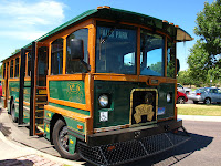
Our first stop for the morning, for our senior coffee, was the city of Sioux Falls and today, the falls were still there and a lovely park has been created around the falls by the city council.  A free "trolley" takes you to the city centre or you can simply stay on the trolley, enjoy the self-guided tour in the leaflet and return to the Falls Park, which is what we did.

Back on the Interstate there was corn and more corn.  Did I mention the corn?  And corn was the theme of the next break at Mitchell where we deviated to look at the Corn Palace.  First started in 1896 and rebuilt, enlarged and shifted a number of times, this civic space has been re-decorated with corn murals  nearly every year since.
The murals are made from 275,000 corn cobs of 12 different colours which are specially grown on a 100 acre farm nearby.  Supplementing the corn cobs is rye straw and highlights picked out in dark red/brown dock flowers.  It is pretty spectacular and even better, it is free.

The next feature of note was to "cross the wide Missouri" (break into song here), but before doing so we pulled off in the little town of Chamberlain  for a photo shoot.

We still had 150 miles to cover (past the corn fields) to our destination in the Badlands but fortunately we crossed another time zone and added an hour to our day so we arrived in plenty of time to have a first look at this utterly fantastic landscape, set up camp, have dinner and then drive back again for some sunset shots.

432 miles today, total trip 2752. States: Minnesota, South Dakota.  

Tuesday, July 31, 2012

Old Man River - 30 July 2012

Today was going to be a long day so after being woken by rain (again!) we were on the road nice and early, heading due west on Route 8 bound for Stillwater and what we thought was the Mississippi.  

Before long the lakes gave way to pasture and the conifers were replaced by corn.  Miles and miles and miles and miles of corn fields interspersed with a few fields of lucerne, beans and grass - but mainly corn (or maize?)

Our first stop was the town of St Croix Falls on the "Mississippi" but when we arrived we discovered that the falls disappeared in the early 20thC when the "falls" (a series of rapids) were flooded for a hydro dam, and that the river was actually the St Croix, a few miles upstream from where it joins the Mississippi.

Nevertheless, it was a great lunch stop and we followed the St Croix river downstream to Stillwater, which was not as appealing as the guide books lead us to believe, so we pressed on down the Great River Road, now following the real Mississippi.

Leaving St Croix Falls we crossed from Wisconsin into Minnesota and there was a dramatic change in the topography and scenery.  The flatish land of Wisconsin became quite hilly and all covered with broadleaf trees.  This continued until we finally left the Mississippi so was probably more associated with the fact that we were in a river valley system than any artificially created State boundary.

We followed the Mississippi south-east (effectively losing ground) down as far as Winona where we dropped down to get on to the I-95 for another boring long straightish westerly run for 170 miles across Minnesota to a town in the middle on nowhere called Jackson.  (Cruise control is a wonderful thing!)  

532 miles today, total trip 2320. States: Wisconsin, Minnesota

Follow the trail

Monday, July 30, 2012

Lake Superior - 29 July 2012

This morning was another fairly early start as we decided to fit a boat-trip into the day.  The campground offered all-you-can-eat pancakes for a reasonable price so we took up that offer then set out to travel almost exactly due west along miles and miles of seemingly endless straight roads.  (One section was 25 miles without a bend.)

We tend to think that NZ's South Island is uninhabited and the roads are empty but it is not alone in this regard. Today was mile after mile with hardly any traffic and long periods when there was not another vehicle in sight in front or behind.   With the cruise control set at 60mph it felt as if we were idling along at 30 as we
passed through an ever changing vista of pines, lakes, forests, swamps and so forth.  To begin with the Lake views were all of Lake Superior but as we neared our destination in Wisconsin the lakes dotted along the road became more frequent as there are over 11000 lakes in this State.

But, back to the boat-trip: We drove an hour west to Munising and arrived 10 minutes before the first sailing of the day for the Pictured Rocks boat trip.  This 2:40 hour trip takes you along the full length of the Pictured Rocks National Park.  The "rocks" in question are actually cliff faces rising up to 200' above Lake Superior and we had an absolutely beautiful morning to enjoy this delightfully relaxing trip with a witty and informative commentary and the views.
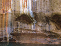
The cliff faces are stained with the leachate from various mineral deposits in the ground; iron (red), manganese (black-white), limonite (yellow-brown), copper (pink-green) and tanin from the ground above (brown). People "see" shapes or pictures in the resulting patina of colours hence the name "Pictured Rocks".  Erosion has also created a number of shaped rocks and outcrops which have been given names, most fairly obvious, like 'The Vase' and 'Indian Head'

Back on shore we made a short detour to take the walk to Munising Falls and have some lunch before setting off for the very pleasant drive to our most delightful campsite yet and the prettiest spot on this trip that this blog has been written.

240 miles today, total trip 1788. States Michigan, Wisconsin.

Sunday, July 29, 2012

The Great Lakes - 27,28 July 2012

The 27th was a pretty unremarkable day as we left Lake Erie and motored north past signs to a bunch of names that were very familiar; Detroit, Grand Rapids, Toledo, Kalamazoo, Ann Arbor and so on.  Unsurprisingly we hit another thunderstorm so we just drove on through fairly uninspiring vistas until we finished not far from the shores of Lake Huron.

The rain finally stopped and we had our second night without a thunderstorm.  Knowing we had a lot of ground to cover we made an early start on a beautiful cloudless day to drive up the shores of Lake Huron to the bridge across the straits that separate Lake Huron from Lake Michigan.

While in New York we saw adverts for any size coffee $1 at MacDonald's so we have frequented a few on the road for cheap coffee and were always surprised at the number of Golden Oldies "hanging out" at the Golden Arches and yesterday we found out why. The other day I was mistaken for an 18-year old and ID checked when buying wine, yesterday I was mistaken for an OAP and offered a 'senior coffee' for only 50c.  So now we are faithful Big M clients for our 50c coffees.

After a break at Alpena we continued north to the bridge between the lakes and stopped briefly at St Ignace to walk the shore boardwalk along the foreshore of the second oldies town in Michigan, before pressing on to Sault Ste Maire to look at the Soo Locks which allow the
massive freighters on the Great Lakes to drop the 21' from Lake Superior to Lake Huron.  Fortunately there was some activity in both the up and down channels while we were there.  It is amazing that the Great Lakes hold 1/5 of the total fresh water in the world and if the contents
were spread evenly over the US it would be 9m deep.  It is also amazing that the freighters can exit to the sea via the St Lawrence seaway or access the Mississippi and exit in the Gulf of Mexico.

Heading west we stopped at the Upper Tahquamenon Falls, which whilst at their lowest summer flow were still quite impressive.  From there it was about an hour's run south to Newberry for the night where we sat on the terrace writing this whilst listening to de la Croix entertain us with Blues, Reggae & Country music.
646 miles in two days, total trip 1548. States: Ohio, Michigan

Friday, July 27, 2012

Amish Country - 26 July 2012

So far we have camped 4 nights and three of them have been during thunderstorms. Why the drought that has affected this area of the US for weeks decided to finish this week is a mystery.

Nevertheless, there was a break in the rain this morning and the tent was almost dry when we packed it up and set off, rather later than normal.  We headed down I-90 and then decided to deviate from our intended route and add a couple of hours to the day by visiting the largest Amish community in America.

However before we got there we had another four thunderstorms to deal with. The first was the most spectacular; the first lightning appeared to hit a transmission mast just up ahead, but it could have been in line and way behind, we could not tell. The third strike was much more dramatic as it exploded a tree beside the motorway less than 20m from the car at about the 2 o'clock position.

The lightning bolt was multi-coloured with red blobs among the blue flash and the report was tremendously loud. An utterly fantastic sight, close enough to be impressive and far enough to not affect us. The temperature dropped 20 degrees to 71F and later rose to 94F.

After that the heavens opened and the visibility was minimal.  This did not seem to deter the truckers in their 18-wheelers who kept to the 65 mph limit and simply powered past us.   The rain passed and we settled back for the 150 miles to our designated exit.  Cruise control on; satellite radio playing classical with no fading as you get too far from the transmitter; a/c on;, 3.5l V6 burbling along at 38mpg - I love America!

Ultimately we arrived in Kidron for our first Amish stop; there is a famous department store there called Lehman's.  One could happily spend hours there looking at all the goodies you could not possibly hope to buy at Walmart.
All the bits and bobs one needs for home-made anything and everything, including a ancient looking, but with very modern drive belts, mobile ice-cream making machine for only $9750.00.  Unfortunately we had many miles to cover so after buying a few bits and pieces we set of to drive through the back country roads to Berlin.

Naturally there were many Amish horse-drawn buggies to pass or overtake and there were families sitting on there porches but the highlight was the family harvesting a crop (hay?) using horse-drawn and powered implements.
The Amish country provided some of the most attractive rural American scenes to date. Because the work is all manual or horse-powered the holdings have to be small and thus the houses and barns are fairly densely packed  making for very pleasant vistas full of neat and tidy farm homesteads and barns.

Arriving in Berlin we stopped in Main St at x &y or the best value meal in the USA.  Amish women in the kitchen turning out plain and nourishing fare at rock bottom prices and with extremely quick service.  US Fast-food at its very best.  All that was left to do was make a dash north to our campsite on the shores of Lake Erie.

 381 miles today, Total trip 902 States: New York, Pennsylvania, Ohio.
A couple of weeks ago we were living in William Penn's home town and the place where he is buried and today we drove through his State, Pennsylvania. (Just caught some TV news where the weather in the area today has been headlined as "Wicked Weather")