Our campsite is very well placed to be up the top of Alpe de Siusi, before the road is closed at 9am. This is Europe's largest high alpine meadow, 8 miles wide and 20 miles long, separating two of the valleys we had driven – Val di Fassa and Val Gardena.
We took breakfast up with us, only to discover there were no picnic sites so ate it in the car-park. The road stays shut until 5pm, the only access being by cable-car, and we felt sure we could fill in the day with walks. As it turned out, we wondered if we would ever make it back to the car!


The first walk we did was called a Panorama walk for those in a hur

ry, and was an undemanding walk, that took us close to the reverse side of the peaks we are camping under. Mountain “huts” or “refuges” are encountered on the walks, and these turned out to be actual lodges with full catering facilities, very pleasant during a long walk. The advice on the web had been to visit here in June to mid July to see the spring wild flowers.

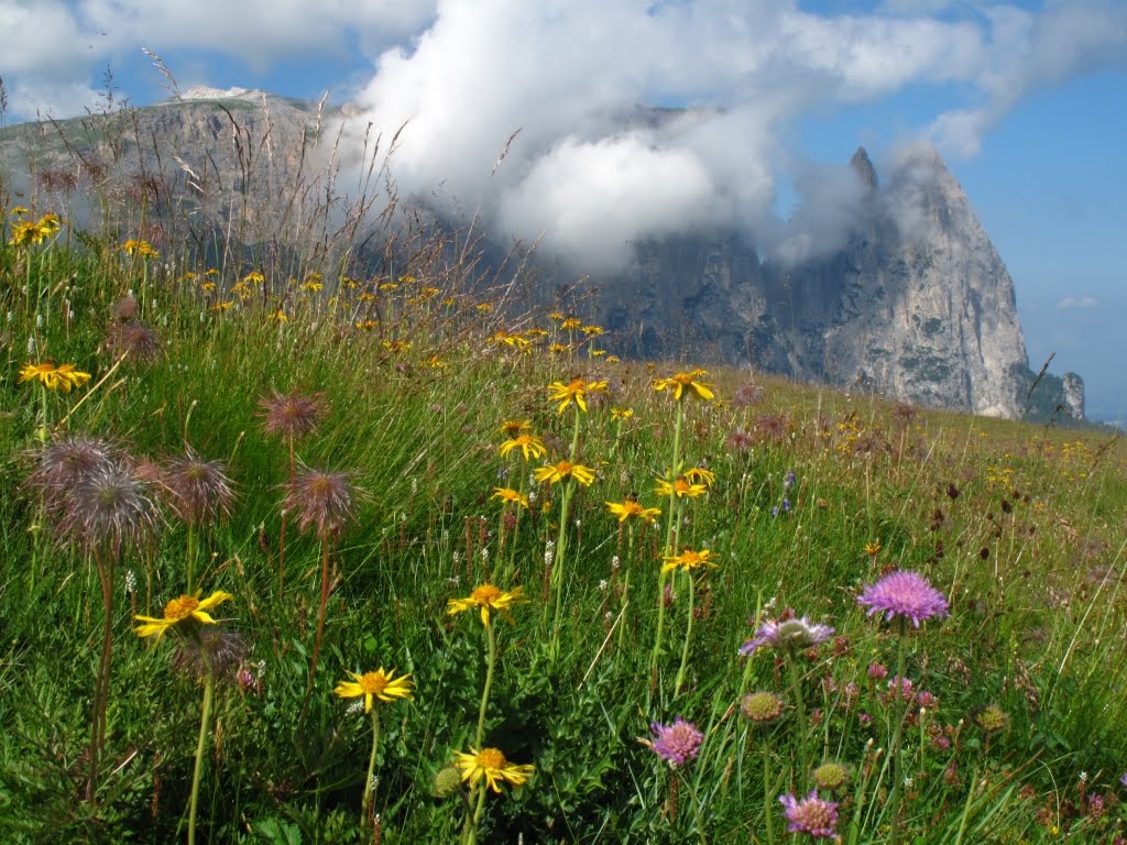
We realised why mid July was the cut-off point, not the heat of summer, but the mowers were out in force, and about a third of the meadows had been cut. They were obviously 'making hay while the sun shone', and in another week, there would be no wild flowers left. This was our first experience of proper alpine wild flowers, and we found them quite stunning.


After another picnic in the car-park for lunch, we set off on a walk described in the map as more demanding, and a total time of 4.5 hours from the head of the meadow at Saltria. The excellent bus service took us to the far side of the meadow for €1, and as we knew it is 8 miles wide, a walk up to Sasso Piatto and then back to the car at Compaccio, didn't seem unreasonable.


The sun was shining, the peaks cleared of the morning mist, and we were really enjoying the walk; despite the fact that we only had shoes, not boots like everyone else! After coffee at the Zallinger Hut, we encountered a really steep track which took us up to the Sasso Piatto hut at 2300 m. (Our start point had been 1740m) The air up here was considerably colder, and although we felt like a hot drink, a guaranteed amount of liquid seemed a better use of our last money so we settled for ice-tea and a sugar boost.

At this point, we realised how sketchy the instructions were. At this furtherest point on the meadow, it merely said, return to Compaccio. No sign boards indicated which track, the track numbering system didn't help. For some unknown reason, no number 4 tracks were indicated in the direction we felt was the right one.

So at 4pm, we set of on the final leg of the journey. It had taken 3.5 hours so far, including 30 minutes of refreshment breaks. This meant we should be 1.5 hours from our car. But on the stylised map (not drawn to scale), it looked an incredibly long way. So we cranked up the pace, passing everyone we encoutered, came across numbered tracks not on our 'pretty' map obtained at the tourist information centre, and made our own way home as best we could. Some clear indication as to which of the tracks leading back to our Compaccio was the most straightforward, would have been helpful. We asked several walking parties, but they were all novices like us, and none spoke English! The best response we got from one party was where do you want to sleep tonight”, i.e. “which refuge are you heading for on your tramp”! We had no packs and only the lightest of clothing, why they thought we would be staying on the mountain was anybody's guess.


When we finally reached the car at 6.30pm, were were extremely tired, but relieved to be there. A summer jersey and lightweight shoes, didn't seem like adequate preparation for an evening in the mountains!
When we finally got back to the camp-site we were very tired and very happy to take advantage of the camp's excellent restaurant.

We were fortunate enough to secure the last terrace table, with a brilliant view over the camp nestled under the Sciliar Dolomite peak, and see the setting sun turn the peaks a rosy pink colour. It was a great finale to our last night in these mountains.

 The rain continued most of the night, but cleared in the morning, and we were able to make use of the walk leaflet we were given at the Longwy Tourist Office. About half of the original town and ramparts still remain in this town.
  It was obviously built on a similar design as Neuf-Brisach. This town has suffered military action more recently though, and we could see hundreds of WWI bullet holes in most of the public buildings.
 The final UNESCO Vauban site on our route back to Dunkirk was in Arras. The sat-nav seemed determined to route us there via Belgium. We decided not to argue, until we discovered the state of rural Belgium roads. We had thought British rural roads were in a bad condition after last winter's freeze, but the Belgium minor roads we encountered were shocking, one of them looked like the craters of the moon! We were relieved to cross back into France, and their excellent roads.

 Arras is a town worth visiting for it's own sake, which was just as well, as we were unable to enter the Vauban Citadel. The design looked very similar on the outside, but the fortress was locked up tight.
 On the second half of our drive today, we passed many war cemeteries and monuments. At Arras, next to the Citadel, we were able to take in the grandeur of the British War Cemetery. 159,000 Commonwealth soldiers were killed in this area during a period of 39 days. The graves only account for 2,670 soldiers, the names of 35,000 missing men are written around the monument. This area is a stark reminder of the grim history of last century.